- New Report
- Regional set of maps
- All the Maps in Zipped File
- Single County Planning Maps
- Shore Protection Methods
- Data
Governments Plan for Development of Land Vulnerable to Rising Sea Level: Connecticut
Lesley Katz Genova et al. 2010. "Connecticut". In The Likelihood of Shore Protection along the Atlantic Coast of the United States. Volume 2: New England and South Atlantic. Edited by James G. Titus, Daniel L. Trescott, and Daniel Hudgens. Report to the U.S. Environmental Protection Agency.
This page summarizes the overall relationship between land use and the likelihood of shore protection in Connecticut. Five separate pages discuss site-specific situations brought to our attention by the regional planning agencies.
 You can also download a printer quality version of this Connecticut sea level rise planning study (pdf 6.1 MB, 73 pp).
Abstract
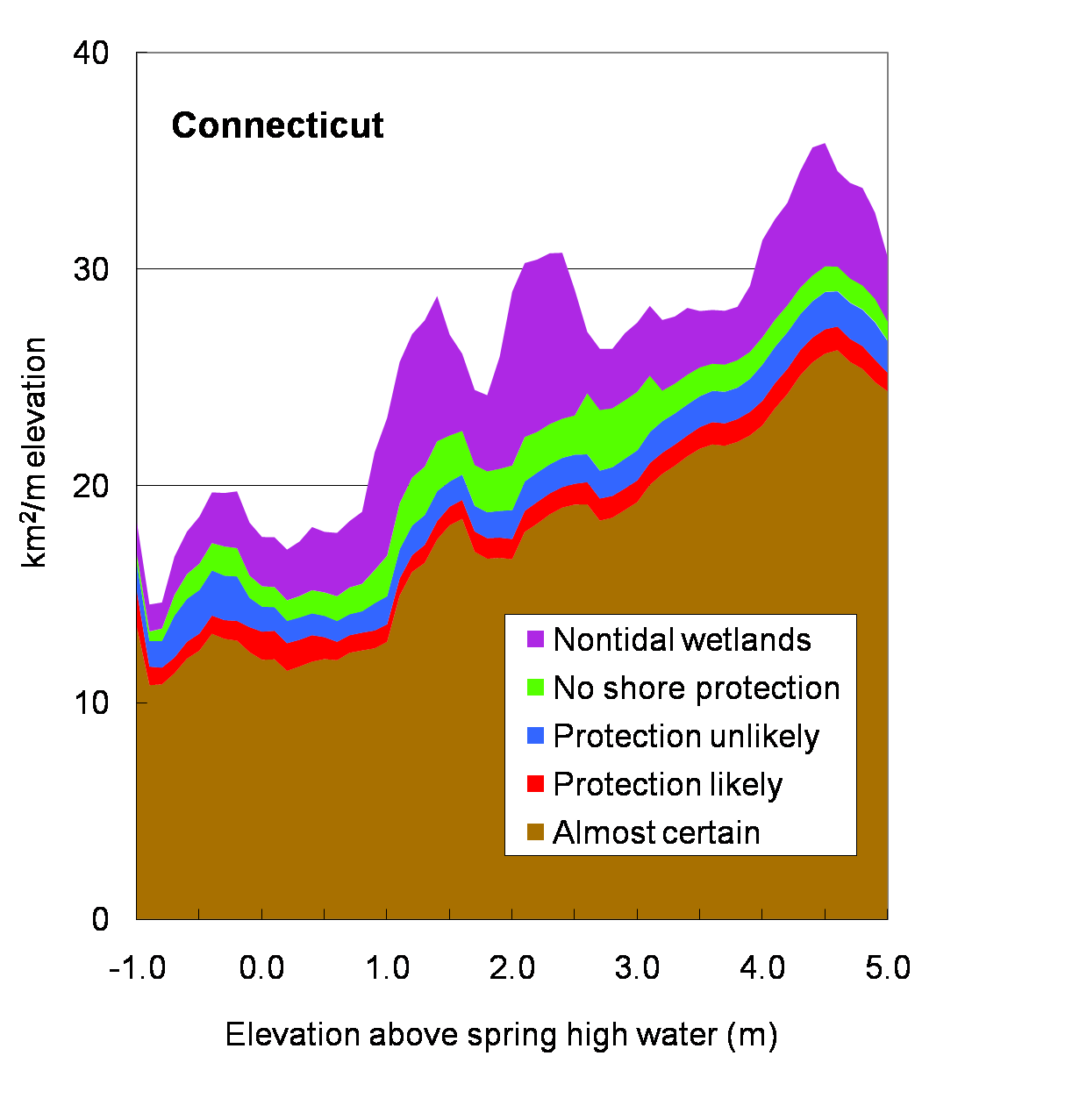
Shore protection is almost certain for approximately 80 percent of the coastal zone of Connecticut, a higher percentage than for any other state along the Atlantic Coast. This conclusion is based on the available land use data for the state, refined by the site-specific understanding of the planners in the six regional planning agencies along the Connecticut Coast: South Western Regional Planning Agency, Greater Bridgeport Regional Planning Agency, South Central Regional Council of Governments, Connecticut River Estuary Regional Planning Agency, and the Southeastern Connecticut Council of Governments. We also collaborated briefly with the Valley Region planning agency. The accompanying chart shows the area of l and in various classifications for each meter of elevation.
Commercial, Industrial, and Residential Lands
Most of these areas are certain to be protected, but a few areas are likely, but not certain, to be protected.
Protection Almost Certain
The Connecticut shoreline is primarily developed for residential use, but also includes pockets of highly developed industrial and commercial land uses. Generally, there is a trend of decreasing development as one moves eastward along the Connecticut shoreline. In the Greater Bridgeport Regional Planning Area, a western region with significant industrial development, residential uses currently occupy more than 52 percent of lands, and commercial and industrial uses occupy 5 percent of lands combined. To the east, in the Connecticut River Estuary Region, residential development currently accounts for close to 20 percent of the total land area, and commercial and industrial lands together occupy just over 2 percent of the area (1995 data). In Southeastern Connecticut, the easternmost region, residential land uses comprise roughly 15 percent of the land area, and commercial and industrial uses account for about 1 percent each.
To obtain a permit to construct structural armoring waterward of the high tide line in Connecticut, a property owner must submit a coastal permit application to the state DEP. As stated above, the flood and erosion control structure should be "unavoidable and necessary to protect water-dependent use, infrastructural facilities, or an inhabited structure(s) that predates January 1, 1980, the effective date of the Connecticut Coastal Management Act (CCMA)." As part of the application, the applicant must evaluate the beneficial and adverse impacts of the project on coastal resources, and show that alternatives such as beach nourishment and vegetation would not work. This could mean actually attempting other remedies or simply analyzing other possibilities. The burden of proof is also on the applicant to show that the property is actually in peril. DEP staff state that although the CCMA allows protection of imperiled pre-1980 flood and erosion control structures, a permit may also be granted for structural armoring to new structures, or structures in sensitive areas, if those structures support public access, another water-dependent use, or affect public infrastructure facilities such as bridges. In addition, nonstructural protection is permitted in most circumstances.
Thus planners assume that private landowners will protect existing developed lands (e.g., through armoring or elevation/beach nourishment). In particular, heavily developed areas, such as Stamford, Norwalk, and Bridgeport, will almost certainly be protected with structural armoring. This includes designated Regional Centers in the State Plan of Conservation and Development, and areas shown as commercial, industrial, mixed urban uses, or medium/high density residential in recent land use data. Designated Rural Community Centers have a higher density of residential and commercial uses than other rural areas and are almost certain to be protected.
A number of relatively densely populated areas in the eastern portion of the state are serviced by septic systems. The DEP would like to move these areas to sewer systems; however, towns are often opposed to such a change because of the fear that sewers will encourage further development. Examples of densely developed areas that rely on septic systems are Groton Long Point and Lord's Point in Eastern Connecticut. With sea level rise, rising water tables could create septic system failures in these areas. Because these areas are highly developed with private homes, however, this analysis assumes that private funding would allow these areas to be maintained and protected when faced with sea level rise.
Affluent lower density residential areas are also assumed to be almost certainly protected because of residents' ability to personally finance protection and also to influence local and state authorities to allow or fund the necessary structures. For example, most of the coastline in the South Western Region, with a median family income of $93,000 (nearly twice the state average) and several coastal towns with median family incomes of more than $120,000, is almost certain to be protected.
Protection Likely
The State Conservation and Development Plan identifies some Growth Areas, where growth is to be encouraged and is considered to be "capable of supporting large-scale, mixed uses and densities in close relationship to the Regional Centers." Because much of the ocean coast is already developed, Growth Areas in southern Connecticut lie predominantly inland or along river corridors. Because of existing development along the coast, very few Growth Areas have been identified west of New Haven. To the east, however, Branford, Guilford, Madison, Clinton, and Westbrook have each identified growth areas within about a mile of the coast. Other growth areas are found along the Housatonic River in Milford, the Quinnipiac River in Wallingford, and the Thames River in Montville and Preston. Currently undeveloped lands located within Growth Areas are shown as protection likely (red).
Infrastructure
Most of the state's public facilities are certain to be protected, but a few areas are likely, but not certain, to be protected.
Protection Almost Certain
Projects that occur waterward of the high water mark that may require structural armoring are likely to receive protection under the CCMA. Structural armoring needed to protect infrastructural facilities may be deemed to be consistent with the CCMA. State planners further indicate that installing riprap to protect bridge supports is a commonly approved activity under present regulations. Thus, bridges, roads, rail lines, communication facilities, and other major infrastructure already are shown as almost certain to be protected by structural armoring (brown). For example, structural armoring is virtually guaranteed for the Millstone Nuclear Power Facility at the mouth of the Niantic River.
Protection Likely
This study does not evaluate the likelihood of shore protection of military lands. The general approach is to color them red so that they show up in areas that are otherwise undeveloped, except for those lands that are within urban areas where protection would be certain even if the land were held by the private sector.
Agricultural Lands and Forests
Undeveloped lands that are currently used for agriculture or are covered by forest and are not currently designated as Neighborhood Conservation Areas, Rural Community Centers, or Growth Areas by the state Plan of Conservation and Development are assumed unlikely to be developed for commercial or residential purposes in the foreseeable future. Thus, these areas are shown as protection unlikely (blue).
Open Space
No Protection
Most undeveloped land in southern Connecticut is located east of New Haven. In Southeastern Connecticut, committed open space accounts for 13 percent of the land area. In the Connecticut River Estuary planning area, this figure is slightly higher, at 17 percent. As a general statewide assumption also applied in this study for other states, we assume that lands set aside as permanent open space will not be armored against rising sea level. Thus all property types that meet this criterion are shown as no protection (light green). Our definition of permanent open space includes preservation lands, land trusts, private open space, refuges, sanctuaries, and Audubon lands.
Protection Unlikely
Municipally owned open space lands are less likely to be permanently set aside for conservation. In some cases, cities may elect to sell valuable open space land to developers to increase the tax base. Thus, we depict city and town open space areas as protection unlikely (blue) rather than no protection. Similarly, lands held in conservation easement are not likely to be armored, but property owners do typically maintain the right to armor. Therefore, we also show lands held in conservation easements as protection unlikely. Areas that are currently barren and are not designated as Neighborhood Conservation Areas, Rural Community Centers, or Growth Areas are also assumed to be unlikely to be protected from sea level rise (blue).
Other Public Lands
Protection Unlikely Many of the smaller islands off the coast of Connecticut are owned by the state. Following the methodology used in other states, state-owned offshore lands that are not parks are depicted as unlikely to be protected from sea level rise (blue).
No Protection
In general, the state and towns do not have mandatory policies preserving current open lands as natural areas. State planners, however, told us that areas currently designated as state or federal parks will not be protected from sea level rise (light green). This includes DEP-owned lands such as state forests, state parks or preserves, and wildlife areas or sanctuaries. Planners also anticipate that lands in Connecticut owned by the federal government, such as National Wildlife Refuges, will not be protected from sea level rise (light green). Two National Wildlife Refuges lie within Connecticut's coastal area: Stewart B. McKinney and Salt Meadow.
Nontidal Wetlands
Connecticut has 450,000 acres of inland wetlands, 85,000 acres of freshwater watercourses, and 17,500 acres of tidal wetlands. As stated above, the Tidal Wetlands Act requires a permit for all activities within tidal wetlands. Wetlands are unlikely to be altered in any way to address sea level rise, and are dark green on the map.
Tribal Lands
The Mohegan Sun Hotel and Casino along the west bank of the Thames River in Uncasville is the only tribal area located within the study area. Tribal governments have considerable autonomy when determining how their lands will be used. Because of the large investment in this facility, this analysis assumes that this tribal area is almost certain to be protected with structural armoring from sea level rise (brown).
Governments Plan for Development of Most Land Vulnerable to Rising Sea (PDF, 7 pp., 1.3 MB) was originally published in Environmental Research Letters , Issue 3, Volume 4 (2009).